
Fortæl dine venner om denne vare:
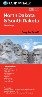
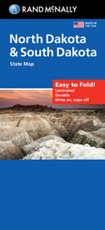
Rand McNally Easy to Read Folded Map: North Dakota, South Dakota State Map
Rand Mcnally
Bestilles fra fjernlager

Rand McNally Easy to Read Folded Map: North Dakota, South Dakota State Map
Rand Mcnally
Rand McNally's folded map for North Dakota and South Dakota is a must-have for anyone traveling in or through the states, offering unbeatable accuracy and reliability at a great price. Our trusted cartography shows all Interstate, U. S., state, and county highways and much more. - Points of interest. - State park chart. - State mileage chart. - Driving times map. - On-the-road toolbox. - Visitor center information. - Climate data. - State facts & symbols. - Easy-to-use legend. - Detailed indexed. Coverage Area: Detailed maps include, Bismarck, ND; Black Hills Region, Fargo, ND; Grand Forks, ND; Pierre, SD; Rapid City, SD; Sioux Falls, SD. Product Details: Measures 9.0 x 4.125 and folds out to 25.5 x 36.75.
| Medie | Bøger Paperback Bog (Bog med blødt omslag og limet ryg) |
| Udgivet | 15. oktober 2021 |
| ISBN13 | 9780528024634 |
| Forlag | RAND MCNALLY |
| Mål | 107 × 239 × 30 mm · 272 g |
| Sprog | Engelsk |
Mere med Rand Mcnally


Andre har også købt
![Cover for Preben Hansen · Turen Går Til: Turen går til Californien & Vestlige USA (Hæftet bog) [5. udgave] (2021)](https://imusic.b-cdn.net/images/item/original/578/9788740063578.jpg?preben-hansen-2021-turen-gaar-til-turen-gaar-til-californien-vestlige-usa-haeftet-bog&class=scaled&v=1623395637)
![Cover for Theis Ørntoft · Digte 2014 (Hæftet bog) [1. udgave] (2014)](https://imusic.b-cdn.net/images/item/original/007/9788702158007.jpg?theis-oerntoft-2014-digte-2014-haeftet-bog&class=scaled&v=1395436941)
![Cover for J. K. Rowling · Harry Potter: Harry Potter 5 - Harry Potter og Fønixordenen (Indbundet Bog) [5. udgave] (2015)](https://imusic.b-cdn.net/images/item/original/260/9788702173260.jpg?j-k-rowling-2015-harry-potter-harry-potter-5-harry-potter-og-foenixordenen-indbundet-bog&class=scaled&v=1441302688)
![Cover for Maria Helleberg · Thy-serien: Søstrene fra Thy (Paperback Bog) [2. udgave] (2022)](https://imusic.b-cdn.net/images/item/original/124/9788702361124.jpg?maria-helleberg-2022-thy-serien-soestrene-fra-thy-paperback-bog&class=scaled&v=1649258403)


![Cover for Kent Haruf · Plainsong - Plainsong (Paperback Bog) [Main Market Ed. edition] (2013)](https://imusic.b-cdn.net/images/item/original/440/9781447240440.jpg?kent-haruf-2013-plainsong-plainsong-paperback-bog&class=scaled&v=1393866782)

![Cover for Disney · Carl Barks & Don Rosa Bind IV (Hardcover bog) [1. udgave] (2021)](https://imusic.b-cdn.net/images/item/original/539/9788793840539.jpg?disney-2021-carl-barks-don-rosa-bind-iv-hardcover-bog&class=scaled&v=1629385760)
Se alt med Rand Mcnally ( f.eks. Paperback Bog , Kort , Hardcover bog , Bog og Spiralbog )